Thursday, January 3, 2019

The Isle fo Mull and Oban, July 2018, Part Two

After we got the ferry back from Iona we took the scenic route to Tobermory.  This was a last minute decision when we saw the road split, and it was well worth it.  This road took us up the west coast of the island, along the coast on tiny, winding roads that were frequently covered in sheep.

The first thing we saw was a sign for otters.  Sadly, we did not see any otters.


There is a tiny hamlet on this side of the island called Burg, so I had to go there. Unfortunately it was down a very narrow tracker and we keep having to pull over for farm equipment, so we turned back.


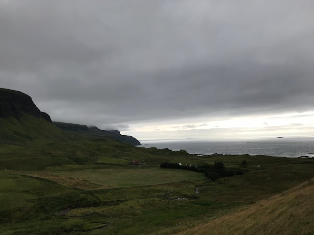
Some pictures of the scenery.

It looks greyer and darker than it actually was in real life.

We got to Tobermory and checked into out hotel.  You can see the hotel in the picture. It looks like a few different buildings as it is painted in bright, different colours.  It was above a pub, and we spent a lot of time in the pub.


(vegetarian) haggis pizza.  I have always wanted to try this, but this is the first time I found it with vegetarian haggis.  I had it twice....or was it three times?
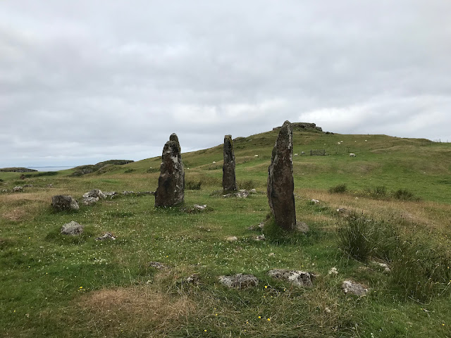
The next day we decided to drive around the northern part of the island. Even though it seems like a small island, there is a lot to see, and this day took more time than we thought it would (I think in total we were out for about 6 hours).  The first stop was just outside Tobermory: Glengorm Castle and Ring Stones.  The castle is now a super fancy hotel, but in the fields just below it is a neolithic ring of standing stones. Not much is known about the stones.


I've upgraded from a tree hugger to a stone hugger, apparently.

One of Tom's favourite cheeses, and one fo mine too, is Isle of Mull Cheddar, which is made (surprise) on the Isle of Mull.  We are planning on having this at our wedding.

I'm good at making friends.

We went to Calgary beach, a white sand beach (who know Scotland had those?) that is where the Canadian city gets its name.  There are a lot of places in Canada named after places in the islands and highlands of Scotland. This is because at the time the British government was looking to populate Canada, they were also letting wealthy landowners in Scotland kick people off of the land they had lived on and farmed for generations.  This was known as the highland clearances, and started in the 18th century, continuing into the late 19th century.  Rich Gaelic land owners saw that they could make more money by turning out the people who were tenants on their land and raise sheep instead (though many of the Gaelic landowners are considered to have been more English, trying to match the culture of the wealthy, more powerful English elites). The same thing happened in England, but that was in the 16th century.  The Gaelic tenants had few choices, and so many immigrated to Scotland, taking their place names with them


We passed the Eas Fors Waterfall, and decided to have a look.


The top of the falls.

The next day we took a walk to the other side of the bay from Tobermory, and then took a tour of Tobermory Distillery.  We had taken the tour in 2012, when we first came, but it was much better this time.

The spirit case.  This is where the actual distilled spirit comes out before being put in barrels.

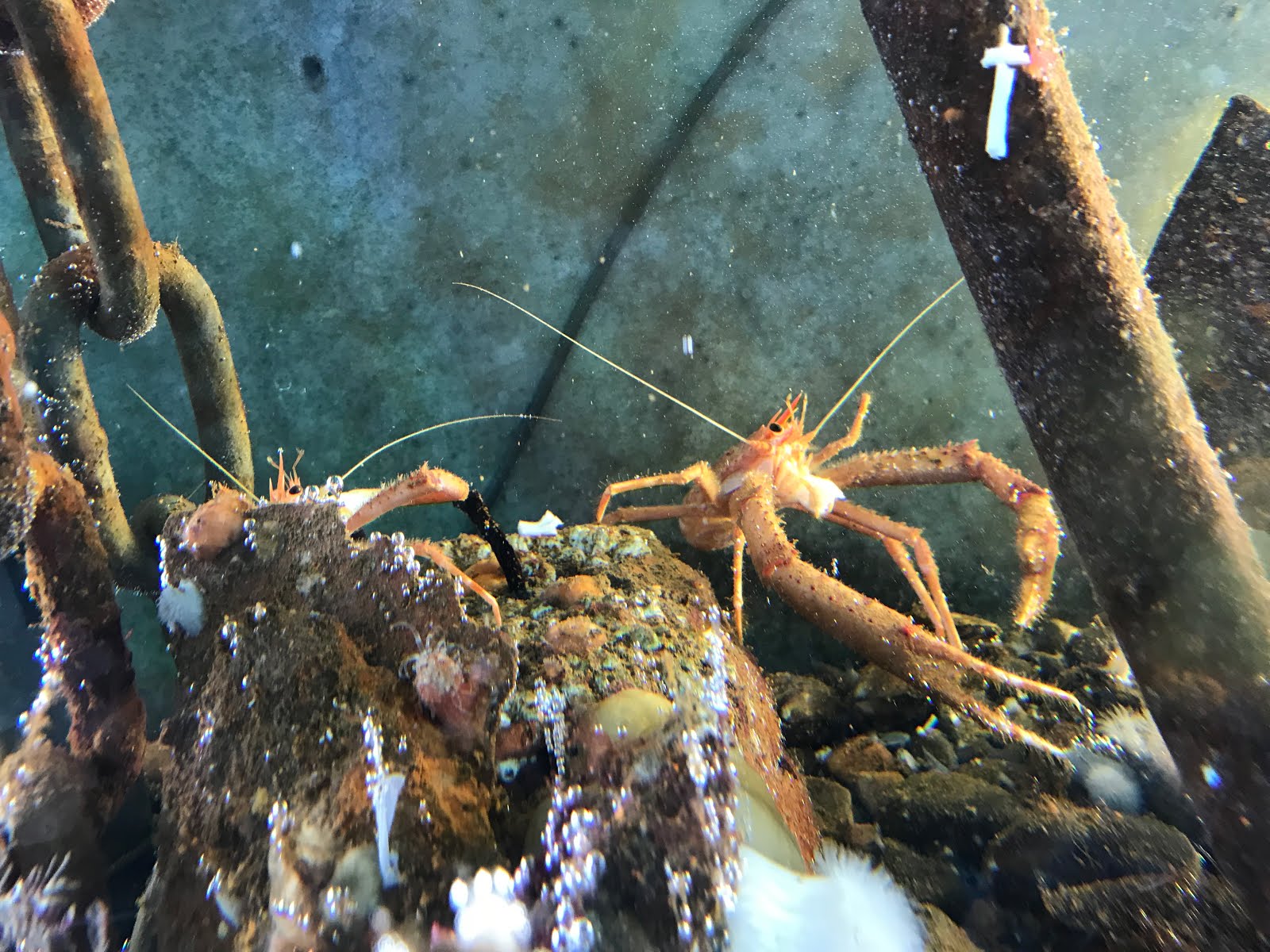
There is an aquarium in Tobermory that is Europe's only catch and release aquarium.  Fishermen and local kids catch stuff and bring it in, where it stays on display for a couple of weeks before being put back in the water.  We got to do an after hours feeding tour.  I would highly recommend it!


Shark eggs.


That was it for this trip.  We really want to see more of the island now that we live so much closer.


Wednesday, January 2, 2019

The Isle of Mull and Oban, July 2018. Part One.


Tom and I decided to go to Scotland for a week for out summer holiday.  Oban is a town on the west coast of Scotland, off the coast of which is the largest of the inner Hebrides, the Isle of Mull.  We had been to Oban twice before, visiting friends who live there.  One of those times we went to Mull, but because of the ferry and bus times we didn't get much time there.  So this time we decided to spend more time.

First we drove to Oban and visited out friend Fee and her adorable little bairns (that's the Scottish word for kid/baby, but they also use it in Newcastle, so I am allowed to use it now without sounding pretentious). It was great seeing them.  We got to spend a night catching up, and then got to read the kids some bed time stories.  I would post some pictures, but posting pictures of someone else's kids online is kind fo creepy, so suffice it to say that they kids are SO CUTE!!!!!

The next morning we headed off to Mull.

Us being us.
Once we got off the ferry we went straight for Iona, a small island off the southwest coast of Mull. The last time we were on Mull we didn't have a car, so we weren't able to get out and see much of the island.  I had wanted to visit Iona for a few years, and so we made sure we went there.  

Iona was settled by Irish monks in 563, lead by St Columba. It became one of the most important sites of western Christianity and remains an important site today.

Iona can be seen on the bottom left of this map.  Our ferry landed at Craignure (centre right on the map). We stayed in Tobermory, at the top fo the map.
We took another ferry from Fionnphort to Iona, which was a very small one, though it could take a few cars.

Iona seen from the ferry. The restored abbey is on the right.
The Benedictine abbey was for monks, but religious women wanted to be part of the secluded community, so an Augustinian nunnery was founded later, in 1203.

The nunnery church.
Although it is very weathered, you can just barely make out the remains of a sheel-na-gig, a fertility symbol that was used in medieval Britain despite its pagan connotations.
To give you an idea of how weird a thing this is to find in a medieval nunnery here is what they usually looked like:


The nunnery church, with the remains of the chapter house in the foreground.
There is a small church, just to the south of the main abbey church, called St Oran's, in the middle of the graveyard.  It's a nice, simple church, which some amazing west highlands grave stones.

St Oran's Church.
West highland grave stones had a distinct style that is only found in the region.
This is the only bit of carved decoration in the church.

Then we got to the abbey itself.  It was AWESOME! In front of the abbey is a mound that is supposed to have been the place where St Columba used as a study, nestled in a writing hut over looking his abbey.

The abbey seen form the top fo the mound.
If you look at the largest doorway, the one on the right, just to the left of that is a much smaller door. This leads into St Columba's shrine.  Celtic churches tended to follow the method used by modern orthodox churches, and instead of placing shrines and chapels/altars dedicated to different saints within the main church, they would be built nearby as stand alone chapels.

The interior of the shrine.

Three standing stone crosses sit on front of the church.  This one is a replica of an earlier one, but next to it is a 1200 year old one (St Martin's Cross).  Unfortunately, I do not have nay good pictures of that.
The church became the focus of renewed religious devotion in the 19th century, and by the 1930s the ancient ruins had been mostly rebuilt, which is why such a complete structure is around today. 

The nave seen from the west end, with the font in the foreground.
The quire and chancel.
A chapel in the south east of the church.
Window in the chapter house.
Some grave slabs in the church.  The one on the right is particularly interesting. The upper portion shows a priest celebrating mass, but the slab has as its central image a sword.  The mass scene would normally denote that the person buried under this was a priest, but as priests were forbidden from carrying weapons (especially edged weapons), it seems unlikely; so it must be a knight/warrior.  However, west highland knights were unique in medieval Christian culture for having no religious imagery on their graves.  The juxtaposition of these images on the same slab is intriguing, and a bit confusing.
St Columba's Pillow.  This was found in a field in (I believe) the 19th century.  It may be one of the oldest pieces of the original church.
The rest of the site is scattered with chapels, a very good museum, and re-built cloisters.  The more modern stuff is a bit boring to me, so there aren't any pictures of it, really.  But here are some more random ones from the island.


The village. 


Tuesday, January 1, 2019

Birthday Trip, Part Two


After Escombe I drove to North Yorkshire to go to Mount Grace Priory.  Mount Grace was a Carthusian monastery founded in 1386. The Carthusian order of monks were possibly the most austere in western Europe. Where other orders of monks lived communal lives, coming together for prayer, work, meals, and services, Carthusian monks were very solitary.  Each monk was given a cell, n reality a small house, to live in. This included (at Mt Grace) an entry chamber, work room, bedroom, and a large attic space to carry out more work, like weaving.  They also had a small covered walk so they could keep (relatively) warm in the winter while looking at at their individual gardens.  They also had their own private out houses and gardens.

Because their lives were so focused on their individual cells the other parts of the monastery are relatively more humble.  They prayed the daily prayers alone in their cells, except for certain times in the day and on Sundays. They were silent, and ate a pescatarian diet.

The priory from the south. The church is obvious, the rest of the ruins are mostly the houses used by the lay brothers (men who did not take orders as monks, but lived by the same rules of the monastery, but who conducted the day to day management of the site), as well as guest accommodation.


Behind the church in the above picture is a wall; this is what is behind the wall, the cloister.  In traditional monasteries you'd have various rooms off of this covered, square walkway: dormitory, chapter house, refectory, et cetera.  In Carthusian monasteries, the quadrangle was formed by the small houses of each monk.  This is why the cloister is so large, as it needs to accommodate main houses fronts.
The former monk's cells are now ruins, except for one that was rebuilt in the early 1900s by the then owner of the property as a way to show his guest what the cells were like (it is the one in the centre of the photo). But first, here are some shots of the ruined cells.

The wall on the right leads into the cloister. You can see the different footprints of the cells, as well as the wall that made the back wall of their gardens.

Most of the cells looked a bit like this one in terms of their layout in relation to the garden: a cell in the corner of the plot, so that the garden is vaguely L shaped.

The same cell, seen form the opposite corner (inside what would have been the cell). The door in the back wall leads to the outhouse that was situated over a small stream.

The doorway from the cloister into the cell. The hatch on the right was used to pass meals to the monks. The door did not lead directly into the cell, instead it lead to a hallway that lead into the cell and the garden.
Here is the recreated cell.  This cell is unusual as its position meant it could accommodate a larger garden than most of the other cells.  For this reason it is slightly more luxurious than the other cells would have been, with a covered walkway complete with glazed windows, and a large open sided walkway on the other side of the garden.  An interesting note to make is that because each cell was a small house it was not uncommon for wealthy patrons to pay for one to be built, and for their crest/heraldic symbols to be placed above the door into the cell.


When you enter the door and turned left you can see the glazed walkway (really it's more of a room). Had you turned right you would go through a door leading to the garden walkway.

The covered, glazed walkway.

The covered walkway into the garden. At the end is the outhouse.  

Ye olde recreated monk's toilet.

This is what remains of the stream that washed under the outhouses.

The garden seen from the corner.  The bit on the right is the covered, glazed walkway. The monks used the garden fro work, as well as to grow plants for food, medicine and dyes/paints.
This is the main living space, you enter it through the doorway to the left of the picture (you can't see it). The first door on the left goes into the bedroom, the second one goes into a work room.


The workroom. The better light in this room means it was likely used for work as opposed to sleep or prayer.
The bedroom. The large chest on the right is actually an altar/prayer table the monks used for their multiple daily prayers.
The attic.  For monks doing work that involved large equipment, like weaving and spinning, the attic would have been a good work space.
The entryway. Here you can see the hallway built between the exterior wall and the cell.

Here's a model showing how the other cells may have been laid out.
There is a large part of the former monastery (I think it is the old guest house) that was used as a private home from the 17th century up until the early 20th century.  Georgina Bell, a desert explorer and the woman who helped create the independent states of the middle east, was born in this house.  


I had a really great time out this birthday!  Already planning next year's historical birthday trip (assuming I can get the day off).